County under flood watch
-

- Workers from PennDOT clear a clogged storm drain at the northbound Claysburg/King exit of Interstate 99 where a vehicle was stranded by high waters on Tuesday afternoon. Greenfield Township Police and firefighters from Claysburg and Freedom Township departments responded. Mirror photo by Patrick Waksmunski
-

- A pickup trunk travels north through the rain on the 2100 block of 18th Street Mirror photo by Patrick Waksmunski
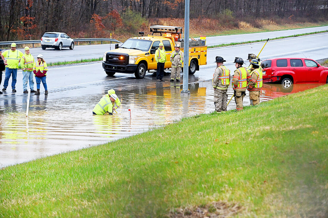
Workers from PennDOT clear a clogged storm drain at the northbound Claysburg/King exit of Interstate 99 where a vehicle was stranded by high waters on Tuesday afternoon. Greenfield Township Police and firefighters from Claysburg and Freedom Township departments responded. Mirror photo by Patrick Waksmunski
Blair County and surrounding areas will remain under a flood watch until 8 a.m. Thursday as forecasters expect up to 3 inches of rainfall to overwhelm already saturated grounds.
“Our biggest concern is the rain,” John Bowen, a meteorologist for the National Weather Service, said. “Expect flooding in poor drainage areas and urban areas. We already have saturated grounds, so less rain is needed for flash floods.”
Bowen said that 1.5 to 3 inches of rain could fall from tonight into Thursday morning, with a few heavy rain showers possible Thursday and Friday.
With temperature lows dropping into the mid-30s, some snow could also be added to the mix Thursday and Friday, Bowen said.
“It will be hard to stick,” Bowen said. “Road temperatures are pretty warm as of the last couple days and ground temperatures are well above freezing, even with snow falling.”

A pickup trunk travels north through the rain on the 2100 block of 18th Street Mirror photo by Patrick Waksmunski
A flood warning was issued for Spruce Creek, which will remain in effect until noon Thursday, Bowen said.
The Hollidaysburg Area School District sent out an email to parents shortly after noon Wednesday, saying there would be early dismissals across all its schools due to the possibility of flooding.
An alert from the Blair County Department of Emergency Services stated that strong thunderstorms could also move through the area, bringing with them the possibility of small hail and gusty winds.
Bowen said that this type of weather is a bit unusual for early April, and that this amount of rain is to be expected in mid- to late-May.
“We’re just getting into that green-up phase and winding down from winter,” Bowen said. “We expect it to be pretty wet, but it’s a little early for incidents of flooding.”
PennDOT District 9 Safety Press Officer Monica Owens said that they have “known areas that get flooded across the whole six-district area that we cover.”
“We have crews out, not anywhere specific, just trying to keep up with the water, trying to open up the inlets in areas where there is poor drainage,” Owens said. “They’re putting up road closure signs in areas where drainage isn’t fast enough and can’t keep up.”
There were some traffic incidents reported locally Wednesday, including a situation in which a car was carried off Interstate 99 near northbound exit 15. The car was carried into a ditch and crews worked to help get the vehicle out.
Owens stressed the danger of attempting to cross standing water, saying that “you will get caught in it” and “it can be a very dangerous situation.”
“Be safe, be smart, even in areas where it’s not necessarily flooded,” Owens said. “There is still the possibility of flash flooding. Slow down, go the speed limit or less because hydroplaning is a big concern in weather like this.”
Bowen agreed, saying that driving at nighttime should be avoided in these conditions if at all possible.
“It’s hard to spot flooded roadways at night,” Bowen said. “It’s hard to determine the depth of water during the day, but it’s nearly impossible at night. Turn around, don’t drown.”
Mirror Staff Writer Rachel Foor is at 814-946-7458.
Local News

Blair County Prison warden commends officers for effort to halt smuggling
Southern Alleghenies Museum of Art marks milestone with Golden Gala
The Southern Alleghenies Museum of Art will be shining bright June 13 with its Golden Gala commemorating 50 years ...

‘Matriarch of Hollidaysburg’ Pat Gildea was dedicated to serving others
Contour Airlines launches seasonal flights to Myrtle Beach from Altoona-Blair County Airport
A taste of summer is only a flight away for area residents, as Contour Airlines is now offering seasonal service ...

Working ahead: Academy of Sacred Music workshops prepare for ‘Messiah’ performance